


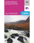
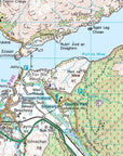
The Ordnance Survey Landranger Map 50 Glen Orchy & Loch Etive is the ideal map for planning the perfect day out. Whether visiting town or country, a wealth of visitor attractions, including National Trust properties, museums, gardens, golf courses and castles, are illustrated. The 1:50k scale mapping provides an ideal compromise between detail and coverage whilst still retaining topographical and contour properties.
Ordnance Survey Landranger Map 50 Glen Orchy & Loch Etive Features:
- West Highland Way, West Highland Way (Long Distance Route), Highland, Central, Strathclyde, Crianlarich
Ordnance Survey Landranger Map 50 Glen Orchy & Loch Etive Specifications:
- Roads, railways and ferry routes
- Paths, national trails and cycle routes
- National Trust areas
- Forestry Commission land
- National Parks
- Tourist information and places of interest
- Camping and caravan sites
- Picnic areas and viewpoints
- Rights-of-way information for England and Wales.
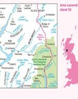
This series features 204 maps each covering 40km x 40km (25 miles x 25 miles) How to access the digital version of this map
This map comes with a digital version which you can download to your smartphone or tablet.
Go to OS.uk/redeem for more details (terms and conditions apply).
Scratch off the panel on the inside cover of the map to reveal a code, you are then just three easy steps away from downloading your digital map.
If the scratch panel has already been scratched off or if you have any problems downloading your map, please call the OS Customer Service Centre on 03456 050505.
We aim to ship out all orders placed before 2pm the same working day! For shipments in the United Kingdom mainland, we use Royal Mail Tracked 24 service (DPD Next Day for larger items and items that weigh over 4KG). Please see our shipping policy for more details.
Summits is your premier destination for outdoor equipment, featuring top-quality brands and exceptional after-sales service. Before you use a product purchased from us, let's cover some key return details and warranty issues by clicking here.